


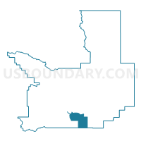
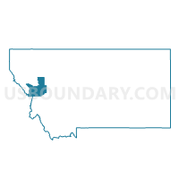
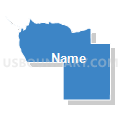
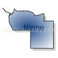
Precinct 33, Missoula County, Montana
About
Outline

Summary
| Unique Area Identifier | 612166 |
| Name | Precinct 33 |
| County | Missoula County |
| State | Montana |
| Area (square miles) | 53.89 |
| Land Area (square miles) | 53.73 |
| Water Area (square miles) | 0.16 |
| % of Land Area | 99.70 |
| % of Water Area | 0.30 |
| Latitude of the Internal Point | 46.70943230 |
| Longtitude of the Internal Point | -113.93852900 |
Maps

Graphs
Select a template below for downloading or customizing gragh for Precinct 33, Missoula County, Montana


Neighbors
Neighoring Voting District (by Name) Neighboring Voting District on the Map
- Precinct 21, Ravalli County, MT
- Precinct 34, Missoula County, MT
- Precinct 35, Missoula County, MT
- Precinct 49, Missoula County, MT
- Precinct 50, Missoula County, MT
- Precinct 8, Missoula County, MT
Top 10 Neighboring County Subdivision (by Population) Neighboring County Subdivision on the Map
- Missoula CCD, Missoula County, MT (82,600)
- Lolo CCD, Missoula County, MT (14,611)
- Stevensville CCD, Ravalli County, MT (14,158)
Top 10 Neighboring Place (by Population) Neighboring Place on the Map
Top 10 Neighboring Elementary School District (by Population) Neighboring Elementary School District on the Map
- Missoula Elementary School District, MT (68,646)
- Lolo Elementary School District, MT (5,126)
- Clinton Elementary School District, MT (2,354)
Top 10 Neighboring Secondary School District (by Population) Neighboring Secondary School District on the Map
Top 10 Neighboring Unified School District (by Population) Neighboring Unified School District on the Map
Top 10 Neighboring State Legislative District Lower Chamber (by Population) Neighboring State Legislative District Lower Chamber on the Map
- State House District 93, MT (11,854)
- State House District 90, MT (10,326)
- State House District 100, MT (9,738)
- State House District 96, MT (9,486)
- State House District 91, MT (9,435)
Top 10 Neighboring State Legislative District Upper Chamber (by Population) Neighboring State Legislative District Upper Chamber on the Map
- State Senate District 50, MT (21,523)
- State Senate District 47, MT (21,290)
- State Senate District 45, MT (20,547)
- State Senate District 46, MT (18,643)
- State Senate District 48, MT (18,628)
Top 10 Neighboring 111th Congressional District (by Population) Neighboring 111th Congressional District on the Map
Top 10 Neighboring Census Tract (by Population) Neighboring Census Tract on the Map
- Census Tract 14, Missoula County, MT (6,750)
- Census Tract 13.04, Missoula County, MT (6,738)
- Census Tract 15, Missoula County, MT (6,539)
- Census Tract 13.02, Missoula County, MT (6,241)
- Census Tract 1, Ravalli County, MT (3,963)